
PACE climate satellite releases first images
Dutch instrument SPEXone reaches First Light milestone
NASA’s PACE climate satellite, with onboard the Dutch instrument SPEXone, has reached the First Light milestone. The world now has access to satellite images distinguishing types and sizes of aerosols. SPEXone also measures the extent to which aerosols absorb and reflect sunlight. This allows scientists to reduce uncertainties in climate models. SPEXone was built by SRON and Airbus Netherlands B.V., with support from TNO.
Since its launch on February 8, 2024 from NASA’s Kennedy Space Center in Florida, PACE has been carefully powered on to ensure all instruments have withstood the severe shocks and exposure to space. This now results in the first scientific images—First Light. ‘Eventually, many of these measurements will add up to a complete picture of aerosols in the atmosphere,’ says Otto Hasekamp (SRON), SPEXone principal investigator. ‘We map per area how much of each aerosol type there is, and combine that information with climate models to calculate their contribution to global temperatures. Then we will know better to what extent aerosols are masking global warming caused by greenhouse gases.’
‘SPEXone works exactly as we conceived and designed and it behaves just like in the latest tests on the ground,’ says Marc Oort, systems architect at Airbus. ‘SPEXone is ready for its important task.’
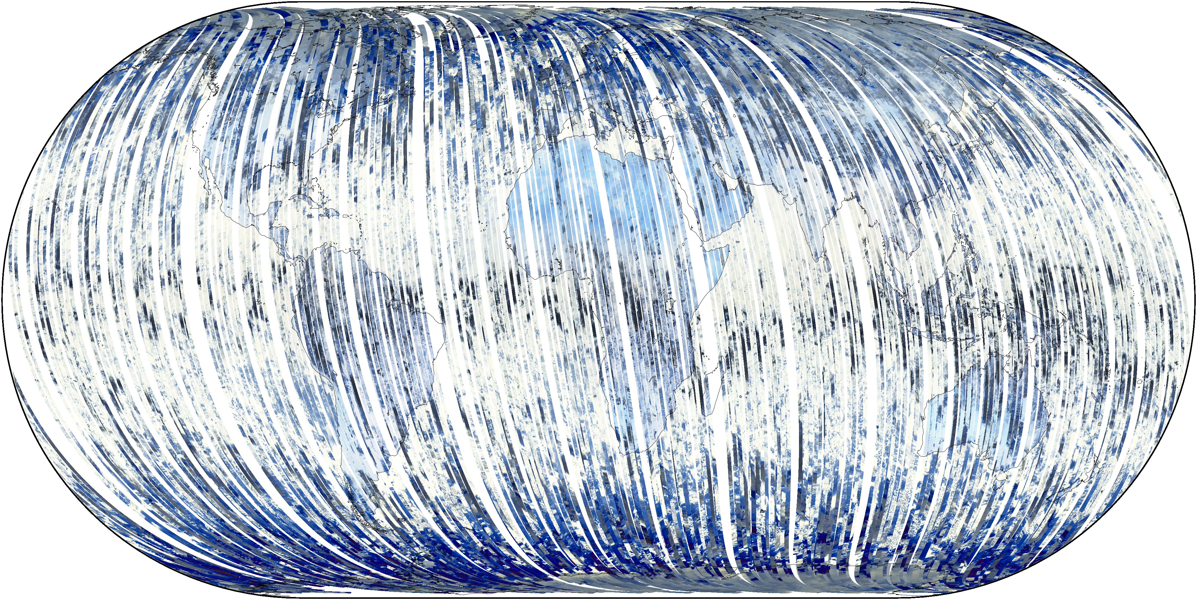
Figure 1: World map in polarized light, compiled from 100-km wide strips that are drawn by SPEXone in its orbit around the Earth. Credit: SRON
Figure 1 shows the world as seen from behind polaroid sunglasses, compiled from SPEXone’s hundreds of orbits around the Earth. The instrument draws a 100-km wide strip across the Earth, like a push broom, in the south-north direction. Different backgrounds such as ocean and land polarize sunlight in their own way, making them look different. For example, land is often blue because only the scattered light in the sky above is polarized.
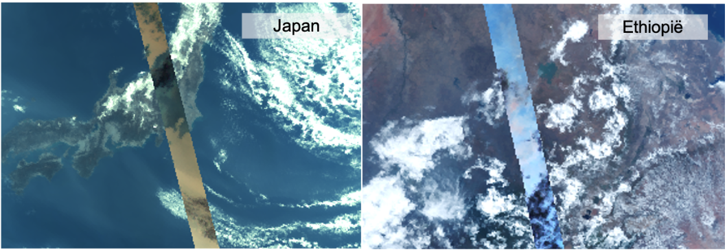
Figure 2: SPEXone casts its 100-km wide field of view over Japan (left) and Ethiopia (right). The instrument measures to what extent sunlight is polarized for multiple colors, from five different viewing angles. Credit: SRON
Figure 2 contains a SPEXone trajectory over Japan and Ethiopia. The rest of the picture was created by the OCI instrument, also onboard PACE. Clouds are black because they don’t polarize any color. Aerosols reveal themselves by polarizing all colors of sunlight. After analyzing this polarization data, the SPEXone team maps the properties of the aerosols, as shown in Figure 3.
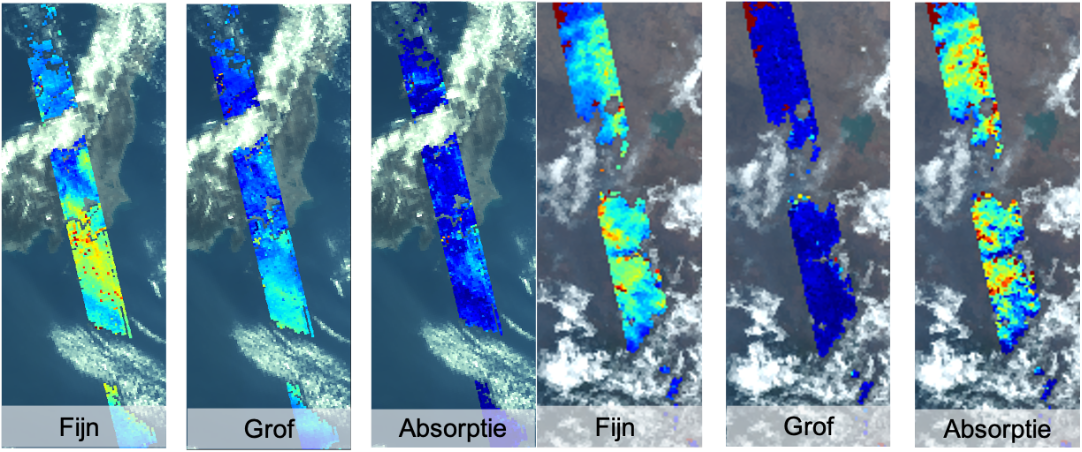
Figure 3: The conclusions from the polarization measurements above Japan (left) and Ethiopia (right). The panels show the amount of fine particles, coarse particles and the amount of absorption. Credit: SRON
Figure 3 shows the properties of aerosols over Japan (left) and Ethiopia (right). Both consist mainly of fine particles. Both left panels show many red and yellow spots, while the middle panels are largely blue. In the right panel we see that the aerosols above Ethiopia absorb lots of sunlight; it has the signature of smoke from the combustion of biomass. Above Japan we see a lot of aerosols around Tokyo blown southwards. The right panel shows the signature of a mix of urban pollution and natural aerosols such as sea spray.
Jeroen Rietjens (SRON) was working in the control room at NASA’s Goddard Space Flight Center while the first data came in. ‘After we entered the command to turn on SPEXone, it was a huge relief to see our instrument in good health. Two weeks later we were even happier when we took the first camera images and managed to create aerosol maps. It was the culmination of years of hard work of the entire team.’
| SPEXone was developed by a Dutch consortium consisting of SRON and Airbus Netherlands B.V., with support from TNO. SRON and Airbus are responsible for the design, assembly and testing of the instrument. The scientific leadership is in the hands of SRON. SPEXone is a public-private initiative made possible by NSO with resources made available by OCW and by SRON/NWO-I and supported by private investments from Airbus Netherlands B.V. |
Share